Automated Pan Evaporimeter vs Penman-Monteith AWS: Measuring Evaporation for Mine and Reservoir Water Balance
Automated pan evaporation vs Penman-Monteith AWS for mine water balance. Compare water level sensor accuracy, Kp factors, and rainfall corrections.
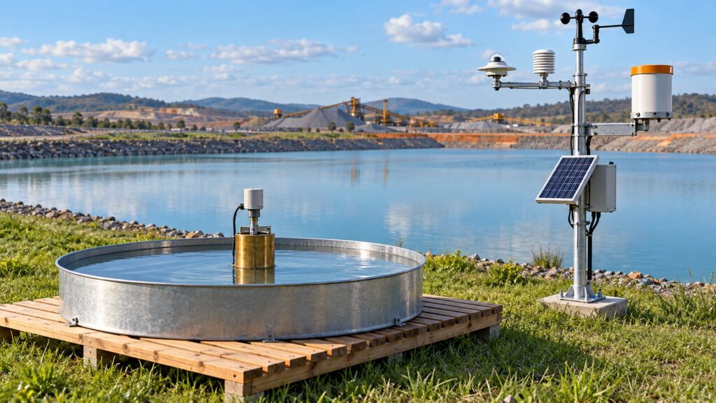
Water evaporates silently, but its impact on mine and reservoir water balances is brutal. Across tropical basins, evaporation eats away 3 to 8 millimeters of water depth every day. On a large open pit or hydroelectric reservoir, that translates into thousands of cubic meters vanishing into the atmosphere each week. To stop guessing with manual micrometer readings, field teams increasingly evaluate automated pan evaporation systems alongside calculations derived from automated weather station arrays. Getting this wrong by even 1 to 2 millimeters per day can wreck settling pond capacity modeling or leave dewatering pump stations completely miscalculated.
Industrial hydrology relies on two main paths today. The first path automates the physical Class A evaporation pan with high-precision water level sensors mounted inside an external stilling well. The second path calculates reference evapotranspiration ($ET_0$) using the international FAO-56 Penman-Monteith equation, pulling data from sensor clusters on an industrial Weather Station. Deciding between them comes down to thermal physics, site access, maintenance overhead, and data continuity.
Evaporation Losses in Mine Water Balance and Reservoir Management
Mine water balance accounting is not just good engineering. In Indonesia, it is a legal requirement under Ministry of Energy and Mineral Resources Decree Kepmen ESDM No. 1827 K/30/MEM/2018 Appendix II. Operators must track surface flows to handle pit runoff, size sediment settling ponds, and maintain safe freeboard margins across Tailings Storage Facilities. The power and water sectors face similar oversight. Ministry of Public Works Regulation Permen PUPR No. 27/PRT/M/2015 on Dams requires continuous reservoir evaporation tracking to support storage safety reviews and discharge quotas.
Consider an open pit lake or tailings pond covering 50 hectares. An evaporation rate of 5 mm per day translates into 2,500 cubic meters of lost water daily. Over a single dry month, that exceeds 75,000 cubic meters. Underestimating evaporation in engineering models causes teams to oversize dewatering pump stations, wasting capital expenditure and diesel. Overestimating it is even more dangerous: settling ponds can overtop during sudden monsoon downpours because the available storage margin was miscalculated.
Class A Pan Standards and Physical Correction Coefficients
The Class A evaporation pan is an open water vessel standardized by the World Meteorological Organization in WMO-No. 8 guidelines and adopted by national agencies such as Indonesia’s BMKG. Its dimensions are rigid. The pan consists of a galvanized steel cylinder measuring 120.7 centimeters (47.5 inches) in diameter and 25.4 centimeters (10 inches) in depth. It sits on an open timber grid platform 15 centimeters off the ground over short grass. That clearance lets ambient air circulate beneath the pan base, preventing thermal conduction with the soil while making leak checks straightforward.
Water depth inside the pan must stay strictly between 5.0 and 7.5 centimeters below the top rim. If the water surface drops below 7.5 centimeters, the exposed metal wall casts a shadow, blocking solar radiation and wind across the water. That artificially depresses evaporation rates. Filling the water higher than 5.0 centimeters from the rim creates the opposite problem: strong wind gusts cause wave splash-out, throwing water over the lip and skewing the data.
Water in a metal Class A pan always evaporates faster than water in a natural lake or deep reservoir. Steel walls absorb lateral solar radiation and conduct heat straight into the water column. The shallow water mass also heats up quickly under the midday sun. To convert measured pan evaporation ($E_{pan}$) into realistic open-water lake evaporation ($E_{lake}$), hydrologists apply an empirical pan-to-lake coefficient ($K_L$):
$$E_{lake} = K_L \times E_{pan}$$
Typical $K_L$ values range between 0.70 and 0.80. Treating raw pan evaporation as direct open-water loss without $K_L$ overstates water losses by up to 30 percent. When estimating reference crop evapotranspiration ($ET_0$), engineers use pan coefficients ($K_p$) between 0.40 and 0.85 based on the FAO-56 Snyder (1992) equation, which accounts for 2-meter wind speed, ambient relative humidity, and upwind green fetch distance. Adding wire mesh screens to keep birds out also blocks solar radiation and air movement. That cuts measured evaporation by roughly 10 percent, requiring an empirical correction multiplier of about 1.10.
Automating Evaporation Pans with Stilling Wells and Solenoid Refill
Conventional manual pan monitoring relies on a hook gauge micrometer read once daily at 07:00 local time. Manual readings introduce human parallax errors and miss diurnal evaporation peaks during the hottest afternoon hours. At remote mine sites, sending technicians on daily trips just to turn a micrometer screw wastes valuable field hours.
Automating the Class A pan requires an external stilling well. A brass cylinder roughly 10 centimeters in diameter mounts beside the main pan, connected through a small capillary port at its base. This dampens wind ripples while maintaining equal water levels. A high-resolution level sensor mounts directly over the well. Teams typically choose non-contact sensors with internal temperature compensation, such as the RIKA RKL-03 Ultrasonic Water Level Sensor, or submersible hydrostatic sensors like the Liquid Level Transmitter placed at the bottom.
Daily evaporation totals only a few millimeters, so the sensor needs a resolution of 0.1 millimeters or better. Digital readings travel via RS-485 Modbus RTU directly into the local data logger.
Autonomous stations also require automated water replenishment. Controlled by the GEOVOS 1000 Datalogger, an electric solenoid valve tied to a clean water reservoir opens whenever the water drops to 7.5 centimeters below the rim. The logger closes the valve once the water reaches the 5.0-centimeter mark, logs the refill event, and temporarily pauses evaporation calculations so the added water is never recorded as an anomaly.
FAO-56 Penman-Monteith Weather Station Calculations
Many industrial sites choose automated weather stations over open water pans. The FAO-56 Penman-Monteith method is recommended by both the FAO and WMO as the global benchmark for calculating reference evapotranspiration ($ET_0$) without an open water body. The formula balances net surface radiation against aerodynamic vapor transfer:
$$ET_0 = \frac{0.408 \Delta (R_n – G) + \gamma \frac{900}{T + 273} u_2 (e_s – e_a)}{\Delta + \gamma (1 + 0.34 u_2)}$$
Computing Penman-Monteith values reliably on a weather tower requires four primary sensor inputs:
- Global solar pyranometer: Measures incoming shortwave radiation ($R_s$) to calculate net radiation ($R_n$).
- Air temperature and relative humidity probe: Housed inside a multi-plate solar radiation shield to determine mean temperature ($T$), saturation vapor pressure ($e_s$), and actual vapor pressure ($e_a$).
- Wind anemometer: Measures wind velocity at a standard 2-meter height ($u_2$).
- Barometric pressure sensor: Calculates the psychrometric constant ($\gamma$) from local atmospheric pressure.
The biggest operational upside of Penman-Monteith is that it requires zero water in the field. The station will not run dry during long droughts, grows no algae, and never attracts wildlife looking for a drink. The GEOVOS 1000 Datalogger runs the FAO-56 algorithm directly at the edge every 10 minutes, pushing accumulated daily $ET_0$ values straight to industrial telemetry networks.
Mitigating Tropical Rainfall Interference
Heavy tropical rain is the biggest operational headache for open evaporation pans. When storms hit, the water level inside the pan surges. The pan water balance during rainfall follows this equation:
$$E_{pan} = P – \Delta H$$
Here, $P$ is rainfall recorded by an adjacent rain gauge, while $\Delta H$ is the change in pan water level ($H_2 – H_1$). Every automated pan station must be paired with an Automatic Water Level Recorder (AWLR) architecture and a collocated tipping bucket rain gauge with 0.1 mm or 0.2 mm resolution.
During intense convective downpours exceeding 50 millimeters of rain, open pans can easily overflow. When water spills over the rim, that day’s evaporation record is ruined because the lost volume was never logged. Modern stilling wells solve this by adding an overflow drain fitted with a pulse-measuring flow sensor to capture every milliliter of runoff.
The GEOVOS 1000 Datalogger handles rainfall data filtering directly at the edge. When the rain gauge registers precipitation pulses, the logger freezes pan drawdown calculations to eliminate false negative readings, recalculating net evaporation once conditions clear.
Comparative Decision Matrix and Integrated Solutions
Choosing between an automated evaporation pan and a Penman-Monteith weather station depends on water access, site logistics, and compliance rules. The matrix below compares both approaches:
| Evaluation Parameter | Automated Pan Evaporimeter | AWS FAO-56 Penman-Monteith |
|---|---|---|
| Measurement Principle | Direct physical measurement of open water level change | Mathematical calculation combining radiation and wind physics |
| Output Metric | Actual local open-water pan evaporation ($E_{pan}$) | Theoretical reference crop evapotranspiration ($ET_0$) |
| Water Supply Demand | Requires dedicated clean water supply and refill reservoir | Completely dry operation requiring zero water input |
| Rainfall Sensitivity | Highly vulnerable to wave splash and storm pan overflow | Completely unaffected by rain events; gauge operates separately |
| Water Balance Factor | Requires lake conversion factor ($K_L \approx 0.70\text{–}0.80$) | Requires crop coefficient ($K_c$) or water body coefficient |
| Data Resolution | Continuous hourly resolution via stilling well level probe | Continuous 10-minute or hourly resolution via edge datalogger |
| Maintenance Needs | Frequent pan cleaning to remove algae, sediment, and dirt | Periodic cleaning of pyranometer glass dome and rain funnel |
| Wildlife Interference | Vulnerable to birds drinking water (requires wire screen) | Zero wildlife attraction or drinking interference |
| Capital Cost (CAPEX) | Moderate (pan, stilling well, level sensor, tank, solenoid) | Moderate to high (tower mast, pyranometer, anemometer) |
| Operating Cost (OPEX) | Higher due to water replenishment and manual site visits | Low, minimal moving parts, and zero consumables |
When a mining concession needs direct physical evaporation data from an outfall or settling pond, an automated pan evaporimeter delivers true local numbers. But in remote pit sectors where clean water is scarce, a Penman-Monteith automated weather station is far tougher and requires less routine upkeep.
Fortuna Argatech designs and delivers complete hydrometeorological monitoring systems for both operational models. Our engineering teams integrate high-precision water level instrumentation for stilling wells and reservoirs, industrial weather stations, and solar-powered GEOVOS 1000 Dataloggers. Before breaking ground, our field engineers conduct comprehensive monitoring site surveys to verify obstacle clearances against WMO standards. Every station includes integrated monitoring station lightning protection and robust monitoring station connectivity across 4G LTE or satellite links, streaming clean data straight into your water accounting software.
Share this article
Share this insight with your team.
Related Articles
Similar topics from the same category.
Monitoring station OPEX budget planning guide covering five cost pillars, cross-station comparison, hidden costs, and a modular worksheet for annual budgeting.

8 mandatory monitoring criteria for PROPER Blue rating under PermenLH 7/2025: SPARING, AQMS, B3, waste, peatland, mining, and SIMPEL audit.

Compare TDR and FDR soil moisture sensor principles, dielectric calibration limits for tropical peat, and multi-depth telemetry integration via GEOVOS 1000.