Cellular, Satellite, or LoRa: How to Choose Connectivity for Monitoring Stations
How to select connectivity for monitoring stations — compare cellular 4G/LTE, satellite, and LoRa by coverage, throughput, power draw, and cost.
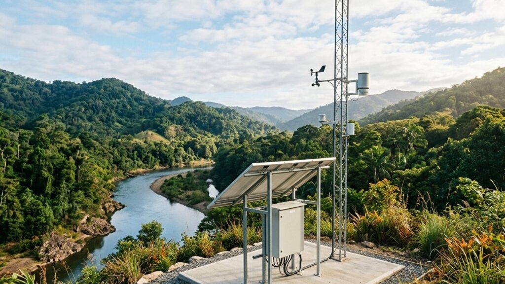
A monitoring station collects data — but that data is useless until it reaches a dashboard, server, or alarm system. Monitoring station connectivity determines whether sensor readings arrive on time or get lost because the communication technology does not match site conditions.
Three main options exist: cellular networks (4G/LTE), satellite links, and long-range radio such as LoRa. Each handles coverage, data capacity, power consumption, and cost differently. This guide provides a decision framework so you can select — or combine — the right technology before equipment reaches the field.
How Each Technology Works in a Monitoring Context
Cellular 4G/LTE uses existing mobile-network infrastructure. Data rates in the megabit-per-second range support frequent sensor transmissions — from intervals of a few seconds to minutes — including image files and large diagnostic logs. Cellular is the default choice wherever reliable mobile coverage exists.
The Fortuna Argatech Geovos 1000 datalogger transmits data via 3G/4G HSDPA/LTE from up to 12 sensors through RS485 interfaces. Its 8 GB internal storage buffers data during connectivity interruptions, ensuring no readings are lost when the cellular link drops temporarily.
Satellite communication operates independently of ground-based cellular infrastructure. Services such as Iridium Short Burst Data (SBD) transmit short messages — up to 340 bytes per mobile-originated message — with global coverage including polar regions. Latency is higher (seconds rather than milliseconds), and per-byte costs are significantly greater than cellular. Satellite SBD is designed for periodic short messages, not continuous data streaming.
LoRa (Long Range) operates in unlicensed ISM frequency bands. Payloads are small — typically under 250 bytes per transmission — but range can reach 2–15 km in line-of-sight conditions at very low power consumption. The tradeoff: LoRa requires gateway infrastructure to bridge sensor data to an IP network, and effective range decreases substantially in hilly or densely forested terrain.
Coverage and Signal Reliability
Coverage is the first decision gate. If no cellular signal exists at the installation point, the speed and cost advantages of 4G/LTE become irrelevant.
In Indonesia — an archipelago with remote mining sites, river catchments, volcanic slopes, and outer islands — reliable cellular coverage is far from universal. Government programs such as the Palapa Ring have extended national broadband reach, but many monitoring locations sit well beyond distribution corridors.
Satellite eliminates dependence on terrestrial infrastructure entirely, provided the antenna has a clear view of the sky and sufficient power is available. For LoRa, the gateway must be within realistic radio range of the sensor nodes. The 10–15 km range claimed under ideal conditions can shrink to 2–5 km when terrain, vegetation, or structures block the signal path.
Data Throughput, Latency, and Transmission Frequency
How much data needs to be sent, and how quickly?
Most environmental sensor readings — temperature, pH, water level, dissolved oxygen — produce only tens to hundreds of bytes per transmission. This volume is well within 4G/LTE capacity, fits within a single satellite SBD message, and matches LoRaWAN payload limits.
Differences emerge as requirements grow:
- Frequent transmissions (every few seconds to minutes) — cellular 4G/LTE handles this without bandwidth constraints. Satellite SBD and LoRa are not designed for sub-minute intervals due to airtime costs and duty-cycle limitations.
- Large files (images, diagnostic logs) — only cellular provides adequate throughput. Satellite SBD is limited to 340 bytes per message; LoRa payloads cap at roughly 250 bytes.
- Latency-critical alarms — cellular delivers millisecond-class latency. Satellite round-trip takes seconds. LoRa latency depends on gateway proximity but is generally low within a local network.
For weather stations or automatic water level recorders transmitting readings every 5–15 minutes, both cellular and LoRa (with an available gateway) handle the data volume comfortably. Satellite also works technically, but per-transmission cost becomes a consideration at shorter intervals.
Power Consumption and Solar Budget Impact
Off-grid monitoring stations typically rely on solar panels and batteries. The communication module’s power consumption directly affects solar panel sizing, battery capacity, and system autonomy.
Cellular modems consume substantial power during transmission — in the range of hundreds of milliwatts to several watts. Satellite transceivers (Iridium class) draw power comparable to or exceeding cellular modems during transmission. LoRa radio modules consume far less power, making them an efficient option where the power budget is severely constrained.
The practical implication: choosing satellite for a site without cellular coverage adds not only airtime costs but may also require a larger solar panel. The complete methodology for sizing solar panels, batteries, and charge controllers is covered in the solar panel sizing guide for remote monitoring stations.
Cost Structure: Hardware, Subscription, and Total Ownership
Do not compare modem prices alone. Communication costs consist of three components that behave differently across technologies:
| Cost component | Cellular 4G/LTE | Satellite | LoRa |
|---|---|---|---|
| Communication hardware | Cellular modem (affordable) | Satellite transceiver (higher cost) | LoRa radio module (affordable) |
| Transmission cost | SIM data plan — generally low per MB | Airtime per message/byte — significantly higher | No per-message fee (unlicensed ISM band) |
| Additional infrastructure | None (towers owned by carrier) | None (constellation owned by provider) | LoRa gateway + internet connection for gateway |
Cellular data costs are generally affordable for monitoring data volumes. Satellite becomes justifiable only when cellular is genuinely unavailable and data must still be transmitted. LoRa eliminates airtime fees, but the upfront gateway investment and its maintenance must be factored in — especially if serving only one or two stations.
Decision Matrix: Matching Technology to Site Conditions
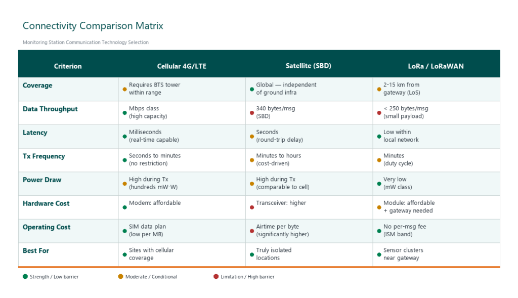
Work through these four questions in order:
- Is reliable cellular coverage available at the installation point? If yes, cellular 4G/LTE is almost always the first choice — highest throughput, lowest latency, most competitive operating cost.
- Must the station transmit data from a location without cellular coverage? If yes, choose satellite or LoRa. Select satellite when the site is truly isolated with no feasible gateway placement. Select LoRa when a cluster of sensors falls within range of a gateway connected to the internet.
- What data volume and transmission frequency are required? If only periodic sensor readings (tens to hundreds of bytes every few minutes), all three technologies are adequate. If large files or near-continuous streaming is needed, only cellular fits.
- What is the available power budget? If power is severely limited (small solar panel), LoRa provides the lowest consumption. Cellular and satellite require a larger power budget.
Hybrid configurations — cellular as the primary path with satellite fallback — can maintain data continuity at critical monitoring sites. This approach adds complexity and cost but reduces the risk of data loss when the cellular network is disrupted.
Fortuna Argatech provides telemetry solutions supporting cellular, satellite, and LoRaWAN connectivity — configured to match each project’s site conditions.
Verifying Coverage Before Deployment
Carrier coverage maps provide a general picture, but actual conditions at the installation point can differ — particularly at the planned antenna height, in valleys, or behind ridgelines. Test the signal with actual hardware at the planned mounting position before committing to a communication technology.
This verification is part of a broader monitoring site survey that covers connectivity alongside power, mounting structure, and measurement-point representativeness. The WMO also recommends reliable and timely data transmission for meteorological and hydrological observation stations, reinforcing the importance of communication verification during planning.
Next Step
Assess your data requirements and test signal coverage at the site before ordering equipment. If you need help determining the right connectivity configuration for a monitoring project, contact the Fortuna Argatech team for a technical discussion based on your site conditions.
Share this article
Share this insight with your team.
Related Articles
Similar topics from the same category.
Poor weather station placement can cause 50% data bias. Learn the WMO-No. 8 and Indonesian BMKG siting standards for AWS sensors in industrial and mining sites.
Explore a technical engineering comparison between solid-state ultrasonic anemometers and mechanical cup-and-vane sensors for industrial weather stations.

Technical guide to conductivity sensors: comparing toroidal (inductive), 2-electrode, and 4-electrode contacting probes for industrial water and wastewater.