Toll Road Tragedy: Why a Landslide EWS Sensor is Absolutely Mandatory
Breaking news regarding severe landslide threats on vital infrastructure. Discover exactly how a Landslide EWS Sensor from Fortuna Argatech prevents fatal tragedies.
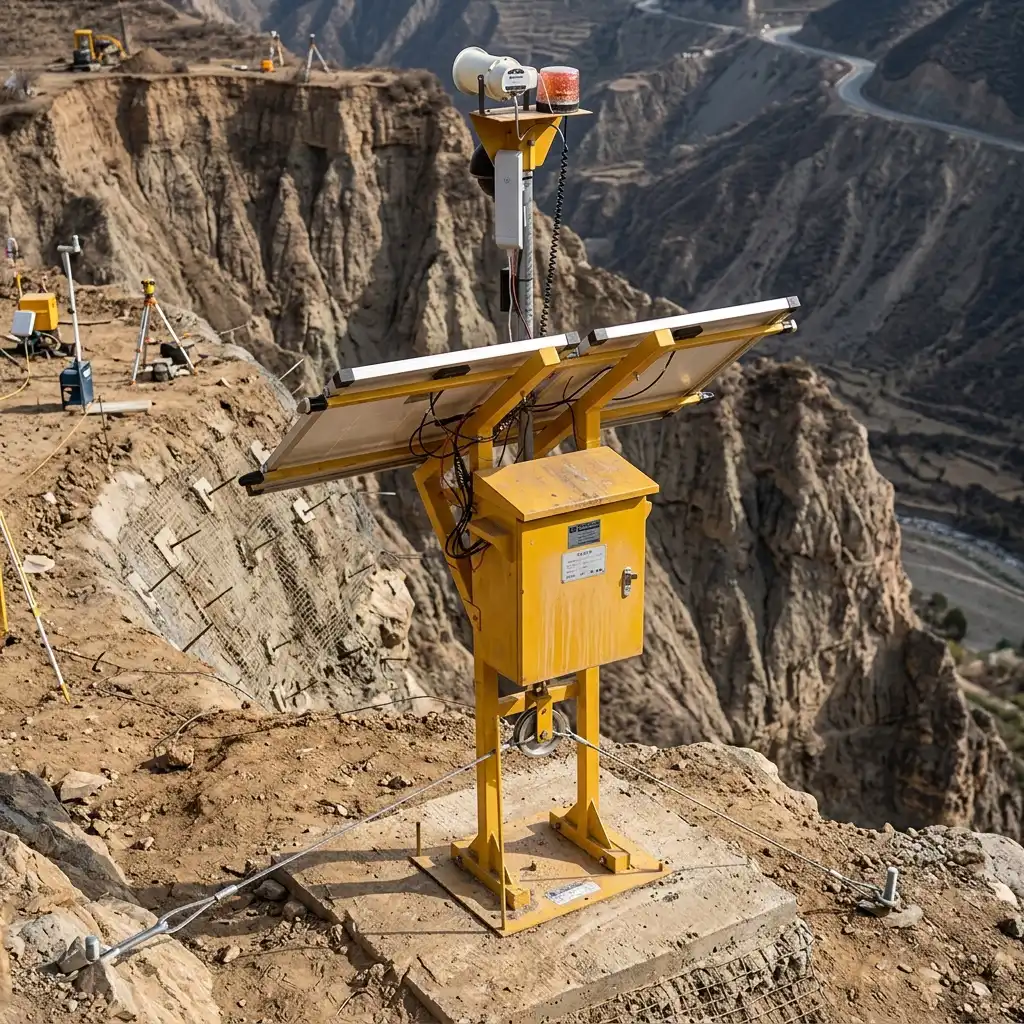
A highly sudden and devastating landslide disaster entirely paralyzing a major toll road has recently brutally exposed the terrifying vulnerabilities within our critical national infrastructure. Worsening extreme weather anomalies combined with massive tropical rainfall aggressively strips away the natural soil cohesion holding steep cliffs tightly together along vital transportation routes. Consequently, massive earthen cliffs collapse completely without warning, burying passing civilian vehicles under thousands of tons of deadly mud. This horrifying and fatal tragedy is completely avoidable if civil engineering operators strictly enforce rigorous geotechnical monitoring utilizing a highly advanced telemetry Landslide EWS Sensor transmitting precise data in absolute real-time.
Catastrophic earth movements occurring on massive civil projects are never sudden, spontaneous phenomena happening out of thin air. The terrifying physical shifting of massive land volumes is fundamentally always preceded by microscopic tension cracks appearing on the ground surface, aggressively widening by sub-millimeter scales across several continuous days. Unfortunately, heavily relying on obsolete visual inspections conducted by exhausted human patrols is profoundly dangerous because the naked eye absolutely cannot detect these microscopic strain anomalies. Therefore, this fatal dependency on manual methodology consistently results in critically delayed emergency evacuations, ultimately causing massive human casualties and the utter destruction of billion-dollar corporate assets.
Directly responding to this terrifying national infrastructure safety crisis, Fortuna Argatech proudly delivers an absolute world-class technological solution specializing in advanced earth movement early warning telemetry. Let us factually dissect exactly why deploying this rugged instrument is a strictly non-negotiable financial investment for every single toll road contractor and open-pit mining operator currently working in Indonesia.
Extensometer Precision in Measuring Microscopic Soil Strain
The absolute beating heart of this sophisticated disaster mitigation system permanently relies on the extreme mechanical reliability of its ground movement measurement hardware, specifically the Extensometer and Displacement Sensor. The physical instruments constituting the Landslide EWS Sensor manufactured by Fortuna Argatech are specifically forged to be incredibly rugged, actively surviving highly destructive extreme weather conditions commonly striking exposed cliffs. The physical Displacement Sensor unit is permanently anchored directly across the highly unstable tension crack zone. This specific mechanical device explicitly utilizes a highly tensioned thick steel wire (sling) extending directly from its internal rotating pulley wheel to flawlessly detect the absolute slightest physical ground separation.
Every single physical soil displacement occurring on a microscopic millimeter scale is instantaneously measured with absolute precision by the tightening physical pull of that steel wire. Subsequently, this highly critical mechanical strain data is flawlessly transmitted straight into the heavy-duty Main Unit Extensometer industrial control panel securely standing completely separated in a safe zone nearby. This brilliant integration of mechanical and digital monitoring mechanisms fundamentally guarantees that absolutely zero dangerous earth movements escape continuous digital observation, even when devastating torrential storms violently strike the cliffside during pitch-black midnights.
Telemetry Early Warnings Aggressively Break the Disaster Chain
The absolute greatest strategic advantage permanently provided by this geotechnical monitoring ecosystem is its flawless data transmission capability functioning non-stop for a full 24 hours every single day. The rugged Data Logger module securely embedded inside the main control panel seamlessly transmits the real-time slope stability status straight to the central command server explicitly utilizing advanced cellular networks or deep space satellite communication links.
The exact millisecond the Landslide EWS Sensor mathematically detects that the terrifying physical soil movement curve has aggressively breached the absolute critical danger threshold, the software architecture explicitly reacts instantly. Extremely high-priority emergency alert notifications are aggressively blasted straight to the smartphones possessed by the toll road operational directors and the frontline safety security teams. Furthermore, this advanced Telemetry ecosystem possesses the hardware capability to instantly trigger massive automated evacuation sirens permanently installed precisely at the disaster site. Securing that highly precious golden time merely a few hours right before the massive cliff ultimately collapses is absolutely critical to securely block highway access gates and aggressively evacuate all personnel, successfully crushing the human casualty rate straight down to absolute zero.
FAQ
Exactly how does the primary soil strain measurement device function physically on a steep slope?
This highly rugged measurement instrument functions by securely anchoring a Displacement Sensor peg directly across a highly unstable cracked soil zone. A thick industrial steel wire is tightly connected directly across that open ground gap. When terrifying physical earth shifting suddenly occurs, the aggressive tension forcefully pulls the steel wire, which instantly rotates the internal sensor pulley, flawlessly converting mechanical movement into precise millimeter digital data seamlessly transmitted to the Main Unit Extensometer.
Does this advanced early warning system permanently require a highly stable fiber-optic internet cable connection?
Absolutely not. The rugged instrument ecosystem heavily engineered by Fortuna Argatech entirely utilizes advanced cellular communication modules (GSM/4G) or long-range high-frequency radio waves (Wireless). This specific hardware completely abandons any dangerous dependency on fragile physical fiber-optic internet cables, making it absolutely ideal for permanent installation on highly isolated mountain cliffs or extremely remote mining excavation projects.
Exactly how do these remote cliffside instruments securely acquire continuous electrical power?
This critical monitoring infrastructure is powered entirely by a one hundred percent independent off-grid energy system. The heavy-duty hardware is physically integrated straight with a highly efficient Solar Panel array and a rugged industrial battery bank system. This specialized electrical engineering design absolutely guarantees the instrument will continue actively transmitting life-saving data for consecutive weeks even if severe overcast storms completely block out the sun.
Who is officially responsible for physically installing these highly sensitive geotechnical sensors at the rugged project site?
The highly dangerous physical installation process for these precision geotechnical sensors is strictly executed exclusively by elite civil engineering teams and certified telemetry field technicians. Fortuna Argatech consistently deploys highly experienced expert engineers to absolutely guarantee the critical sensor wire anchor points are bolted exactly across the most dangerous slope fracture zones explicitly dictated by advanced geological calculations.
Can the digital alarm triggered by this device be physically wired directly to public civilian evacuation sirens?
Absolutely. Specifically utilizing an advanced automated control module operating on an Internet of Things (IoT) architecture, the physical electrical relays located at the central command center can be mathematically programmed to instantaneously trigger massive long-range sirens surrounding nearby villages or toll gates the exact second the sensor detects physical soil movement breaching the absolute highest danger parameters.
Sources and Bibliography
- United States Geological Survey (USGS). (n.d.). Landslide Hazards Program: Real-Time Monitoring Infrastructure and Mitigation Strategies.
- Fortuna Argatech. (n.d.). Geotechnical Instrumentation and Telemetry Landslide EWS. https://argatech.com
- Ministry of Public Works and Public Housing (PUPR). Official Guidelines for the Strict Geotechnical Monitoring of Highway Slope Stability.
Share this article
Share this insight with your team.
Related Articles
Similar topics from the same category.
An operational guide to developing extensometer TARP thresholds based on deformation velocity and the inverse velocity method to prevent false alarms.
KLHK enforced 921 pollution cases with IDR 84.7 billion in fines. Textile Wastewater offenders face IDR 3 billion penalties without real-time SPARING monitoring.
Tailings Dam EWS must be installed for mining disaster mitigation. Discover industrial telemetry solutions from Fortuna Argatech.