Preventing the Smoke Crisis: Forest Fire Early Warning System
Discover exactly how the Forest Fire Early Warning System telemetry from Fortuna Argatech detects extreme weather conditions to preemptively prevent fire hotspots.
Forest Fire Early Warning System – Every single time a prolonged dry season arrives fueled by the intense El Nino phenomenon, the skies across various regions of Sumatra and Kalimantan frequently turn pitch black. The catastrophic haze disasters caused by massive Forest and Land Fires (Karhutla) do not simply annihilate the pristine habitats of protected wildlife. They severely paralyze regional economies and trigger acute respiratory tract infections for millions of innocent citizens.
The government, operating through relevant environmental agencies such as the Ministry of Environment and Forestry (KLHK), continues to fight aggressively to prevent this horrific annual disaster. One of the absolute most effective mitigation strategies specifically mandated for massive plantation companies and logging concessions is the installation of a smart telemetry-based Forest Fire Early Warning System (EWS).
As a premier local instrumentation manufacturing company deeply committed to natural conservation, Fortuna Argatech engineers sophisticated early warning systems capable of sniffing out the potential of a massive inferno long before the very first spark is ever ignited. Let us explore precisely how this crucial technology operates.
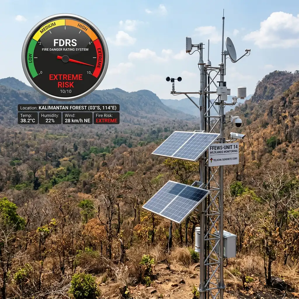
Calculating the Lethal Risk Before the Flames Ignite (The FDRS Concept)
Fundamentally different from a standard fire alarm situated inside an office building that only rings loudly after detecting thick smoke, a Forest Fire Early Warning System operates entirely on a philosophy of proactive prevention. If you stubbornly wait until you finally see smoke rising from the middle of a thousand-hectare forest, you are already entirely too late because the flames have grown massive and are incredibly difficult to extinguish.
Consequently, this system strictly utilizes the standard calculations of the Fire Danger Rating System (FDRS). This specific system meticulously evaluates exactly how dry the natural fuel on the forest floor has become (such as dead leaves, broken twigs, and deep peat soil) based purely on current local weather conditions. Armed with this predictive calculation, logging companies can aggressively elevate the alert status of their patrol teams long before a physical fire hotspot actually materializes.
The Extreme Weather Parameters Constantly Monitored
To seamlessly generate highly accurate fire danger index calculations, the robust telemetry stations from Fortuna Argatech are tasked with continuously gathering massive amounts of microclimate data. The primary vital parameters strictly monitored include:
- Air Temperature and Extreme Humidity: Extremely hot temperatures seamlessly combined with drastically plunging air humidity levels will rapidly transform dry vegetation into highly flammable kindling, burning as fast as liquid gasoline.
- Consecutive Rainless Days (ARR Sensor): Our automated rainfall gauge sensors will precisely calculate exactly how many consecutive days the forest zone has not been blessed with rain. The longer the brutal drought lasts, the faster the peatland dryness levels will shatter critical danger thresholds.
- Violent Wind Speed and Direction: If a tiny, microscopic spark appears amidst a fierce, dry windstorm, the fire will aggressively sprint forward, devouring hundreds of tall trees in a matter of minutes. The wind direction sensor heavily assists the emergency firefighting teams in predicting exactly where the raging inferno will travel next.
Rugged Data Transmission from Isolated Deep Forests
Deploying a towering Forest Fire Early Warning System station in deeply isolated jungle areas or in the middle of a gigantic palm oil plantation naturally brings severe communication hurdles.
The brilliant engineers at Fortuna Argatech flawlessly solved this obstacle by designing data logger stations that operate one hundred percent autonomously utilizing solar power panels (completely off-grid). Our robust devices then instantly beam that critical climate monitoring data utilizing cellular GSM networks or long-range Radio Frequency (LoRa) transmissions directly to the corporate central servers.
The exact moment the FDRS danger indicator on your command room computer screen violently hits the “Red” (Extreme Danger) level, the plantation manager can instantly order the elite fire response team to stand by on high alert within that specific forest block.
Never allow your billion-rupiah plantation assets and highly valuable ecosystems to burn down into worthless ash. Take the absolute earliest preventive steps utilizing the most advanced environmental telemetry systems from Fortuna Argatech today!
FAQ
Is this specific system inherently equipped with a thermal smoke detection camera (CCTV)?
The primary focus of our EWS system is strictly on micro-weather measurement instruments (FDRS). However, our data logger systems are deliberately built using an open architecture, making it highly possible to seamlessly integrate them with your corporation’s pre-existing thermal smoke detection camera poles.
Where is the absolute best physical location to erect this monitoring station?
The most optimal installation location is situated in an open clearing area inside the forest concession or plantation that perfectly represents the overall weather conditions of that block, intentionally far away from gigantic tree canopies that might physically block the wind sensors and solar panels.
How does this delicate instrument survive if a massive fire rapidly approaches the station?
Although the tall station pole and Fortuna Argatech panel boxes are forged from heavy-duty industrial metal, the scorching radiant heat of a forest fire can easily melt the plastic exterior sensors. We highly recommend constantly maintaining a clean, grass-free zone (a miniature firebreak) within a strict three-meter radius surrounding the station pole.
Is the historical weather data gathered by this device legally recognized by the KLHK Ministry?
It is highly recognized. Every single weather sensor we deploy strictly complies with international WMO calibration standards, explicitly ensuring the saved historical data can be confidently utilized as an official environmental compliance report submitted to government agencies.
Can this deeply isolated station transmit critical data without any GSM cellular signal?
Yes. For deeply isolated forestry concessions located in complete telecommunication blank spots, we will effectively utilize miniature VSAT Satellite transmitter modules that absolutely guarantee the data will securely enter your servers every single hour without fail.
Sources
- Ministry of Environment and Forestry (KLHK). (n.d.). Forest and Land Fire Danger Rating System (SPBK).
- Fortuna Argatech. (n.d.). Forest Fire Early Warning Solutions. https://argatech.com
- World Meteorological Organization (WMO). Standard Guidelines for Forest Weather Observation Instruments.

Share this article
Share this insight with your team.
Related Articles
Similar topics from the same category.
Discover the exact technical reasons why securing a Water Level Sensor installation is absolutely critical to preventing devastating flash floods and protecting dams.
Learn exactly how automated Aquaculture Water Quality technology from Fortuna Argatech proactively prevents massive shrimp die-offs caused by oxygen drops.
Learn exactly how an Automatic Rainfall Recorder from Fortuna Argatech monitors rain intensity to secure mines and plantations from flash floods.