More Than Just Erecting a Mast – AWS Sensor Siting Guide to WMO and BMKG Standards
Poor weather station placement can cause 50% data bias. Learn the WMO-No. 8 and Indonesian BMKG siting standards for AWS sensors in industrial and mining sites.
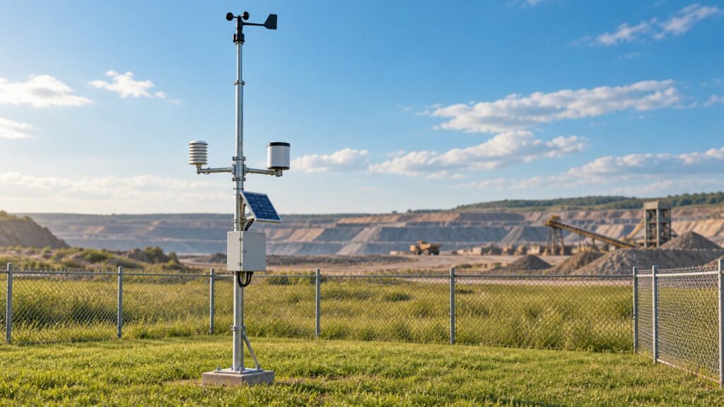
Why Weather Sensor Siting Determines Data Validity
You can buy the most expensive, factory-certified weather sensors on the market. If you bolt them in the wrong place, they will feed you garbage data. The physical laws of the atmospheric boundary layer do not care about your sensor’s data sheet. Plop an automatic weather station onto a flat concrete factory roof, and daytime temperature readings will artificially spike by 5°C purely from thermal re-radiation. Mount an anemometer too close to a tree line, and wind speeds instantly drop 30% to 50%. The technical specs do not matter if the physical exposure is wrong. Proper siting is the only way to get reliable climate data.
The World Meteorological Organization (WMO-No. 8) and ISO 19289:2015 created a formal siting classification scheme to fix this. They break site representativeness down into five classes. Class 1 is the gold standard. It requires an open area completely free of obstacles, pulling the uncertainty margin down to almost zero. Classes 4 and 5 are the bottom of the barrel. They indicate heavy localized bias from nearby obstacles and artificial surfaces. A Class 5 rating means the data cannot be trusted to represent the broader macroclimate.
In Indonesia, BMKG Regulation No. 13 of 2021 draws a hard line on weather station layouts. For industrial and mining operators, obeying these siting rules is about legal compliance and operational safety. Under Kepmen ESDM No. 1827 K/30/MEM/2018, mines must track local weather to manage runoff and predict slope stability. For air quality, Permen LHK No. 14 of 2020 demands hyper-accurate surface wind data to run factory dispersion models. If you ignore the siting rules, your microclimate bias will cause your environmental compliance audits to fail.
Wind Sensors at 10-Meter Height and the 10-Times Obstacle Rule
Wind sensors are the easiest instruments to compromise. Under WMO-No. 8 and BMKG Regulation No. 13 of 2021, you must mount surface wind sensors exactly 10 meters above flat, open ground. That specific elevation pulls the sensor out of the intense friction and surface drag dragging across the earth.
To keep that aerodynamic profile clean, strict obstacle clearance rules kick in. The horizontal gap between the wind mast and the nearest obstacle must be at least 10 times the height of that obstacle ($d \ge 10 \times h_{\text{obst}}$). If a silo is 6 meters tall, the mast stays 60 meters away. This prevents wind readings from being shredded by the turbulent deceleration wake trailing behind the object. If you absolutely have to install the station in a dense forest canopy, the 10-meter rule shifts. The anemometer must sit 10 meters above the zero-plane displacement height, typically calculated as $d_0 \approx 0.7 \times h$ of the canopy.
The most common industrial engineering mistake is bolting an anemometer directly onto the edge of a factory roof. Building geometry forces oncoming wind to aggressively rip over the edge, creating a localized aerodynamic separation bubble. An anemometer sitting inside this acceleration zone will spit out wind speeds distorted by 30% to over 50%. A proper 10-meter ground mast is the only way to avoid structural aerodynamic bias.
Temperature and Humidity Sensors Placement
Wind sensors need the freestream air. Temperature and humidity sensors need proximity to the ground. But they cannot be corrupted by it. WMO-No. 8 dictates these sensors sit between 1.25 and 2.0 meters above the ground. In Indonesia, BMKG mandates an exact 1.5-meter height for the temperature enclosure.
These delicate electronics must live inside a multi-plate solar radiation shield. The shield blocks direct sunlight, scattered sky radiation, and ground reflection. Without it, the sensor measures the temperature of baking plastic instead of ambient air.
The ground surface beneath the shield is a major factor. To hit Class 1 criteria, the sensor must sit over natural, short grass (under 10 cm) covering a minimum 10-meter radius. Natural grass holds a stable albedo. Install that same sensor over black asphalt, dry gravel, or a concrete roof, and the intense infrared thermal re-radiation takes over. This artificial heating effect inflates midday temperature logs by 2°C to 5°C, instantly downgrading the station to Class 4 or 5. A Class 1 temperature sensor must sit at least 100 meters away from sprawling heat sources like parking lots.
Automatic Rain Gauge Orifice Height and Wind Deflection
Precipitation data drives mine water balance calculations and flood detection. It is heavily vulnerable to aerodynamic interference and mechanical misalignment. WMO-No. 8 sets the rain gauge orifice height between 0.5 and 1.5 meters. The Indonesian BMKG locks the standard orifice height at exactly 1.2 meters.
To prevent rain shadows, the gauge must sit away from obstacles by a distance of at least twice the obstacle’s height. Four times is ideal. The elevation angle of any nearby object relative to the gauge orifice should never exceed 30°.
Wind deflection is a silent data killer. High winds sweeping across the open gauge orifice create aerodynamic lift. This updraft physically blows falling raindrops away from the funnel. This is called wind-induced undercatch. When wind speeds crack 4 m/s, undercatch bleeds off 5% to 20% of your actual precipitation data. In highly exposed coastal or hilltop sites, bolting an Alter wind shield around the gauge dampens the turbulence and corrects the bias.
Mechanical tipping bucket gauges also demand perfect leveling. The internal seesaw mechanism requires a rock-solid mounting base with a tilt tolerance of less than 0.5°. A 1° deviation causes asymmetrical tipping, destroying the volume calibration by 5% to 10%.
Solar Radiation Pyranometers and Barometers
Global solar radiation sensors (pyranometers) require a 360° unobstructed hemispherical view of the sky dome. That is a full $2\pi$ steradian field of vision. Surrounding objects cannot exceed a 5° elevation angle anywhere along the sun’s daily path.
On a shared weather tower, the pyranometer sits at the absolute highest point. Or, it hangs on the furthest extended arm pointing toward the equator (south-facing in the north, north-facing in the south). This prevents moving shadows from the main mast, lightning rods, or telemetry antennas from eclipsing the glass dome.
Atmospheric pressure barometers don’t care about open skies, but they demand precise topographic surveying. You must geodetically survey the exact elevation of the barometer’s pressure port down to a 0.1-meter accuracy relative to mean sea level (MSL). A 1 hPa shift equals roughly 8.3 meters of elevation change. Bad elevation data permanently skews the altimetric conversion back to standardized sea level pressure (QNH/QFF). The pressure port also requires a ventilated static pressure head mounted outside the main enclosure. Without it, heavy gusts trigger a Bernoulli vacuum effect that artificially drops the recorded pressure.
Sensor Siting Matrix and Argatech Integrated AWS
Proper AWS siting forces engineers to balance conflicting physical requirements. This decision matrix lays out the compromises.
| Meteorological Parameter | Standard Siting Height | Obstacle Clearance Ratio | Ideal Ground Surface | Potential Placement Bias |
|---|---|---|---|---|
| Wind Speed & Direction | 10.0 meters | $d \ge 10 \times h_{\text{obst}}$ | Flat, open terrain | Up to 50% speed inflation if placed in a structural wake or roof separation bubble. |
| Air Temp & Humidity | 1.25 m – 2.0 m (BMKG: 1.5 m) | > 30m to 100m from heat | Short natural grass (<10 cm) | 2°C to 5°C thermal spike over asphalt or concrete rooftops. |
| Precipitation | 0.5 m – 1.5 m (BMKG: 1.2 m) | $d \ge 2\times$ to $4\times h_{\text{obst}}$ | Flat, leveled (<0.5° tilt) | 5%–20% wind-induced undercatch; asymmetric volume error if tilted >1°. |
| Solar Radiation | Top of mast | < 5° elevation angle | Open sky | Shadow blocking from the lightning rod or nearby antennas. |
| Atmospheric Pressure | Inside enclosure | N/A (Requires MSL survey) | N/A | Dynamic Bernoulli pressure drop during heavy wind gusts. |
All-in-One compact weather sensors create massive physical compromises. They fuse wind, temperature, and rain sensors into a single block. Install that block at a convenient 2-meter height, and WMO wind compliance is destroyed because the sensor only catches slow surface drag. Mount the block at 10 meters, and the temperature readings lose their human-level relevance while rain gauge undercatch skyrockets.
Fortuna Argatech builds integrated weather station systems engineered to navigate these exact conflicts. We wire robust RS485 Modbus RTU sensors into the industrial-grade GEOVOS 1000 datalogger.
We handle the monitoring site survey feasibility studies to ensure WMO, ISO, and BMKG compliance. We manage the civil installation, provide lightning protection for monitoring stations, and deploy independent solar power. We secure monitoring station connectivity via cellular GSM or satellite telemetry. Finally, we run rigorous edge data validation algorithms at the datalogger level. Your environmental compliance reports will be built on unimpeachable atmospheric data.
Share this article
Share this insight with your team.
Related Articles
Similar topics from the same category.
Explore a technical engineering comparison between solid-state ultrasonic anemometers and mechanical cup-and-vane sensors for industrial weather stations.

Technical guide to conductivity sensors: comparing toroidal (inductive), 2-electrode, and 4-electrode contacting probes for industrial water and wastewater.
A technical comparison guide on In-Place Inclinometer (IPI) vs Manual Probe Inclinometer for slope deformation monitoring, risk mitigation, and telemetry.