Water Level vs Discharge: What Does an AWLR Measure?
Learn why an AWLR measures water level rather than discharge directly, and how field gaugings create a site-specific rating curve for monitoring.
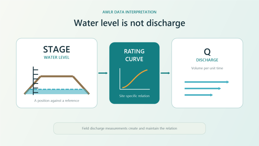
Water level and discharge are related, but they are not the same measurement. An Automatic Water Level Recorder (AWLR) usually records the position of the water surface against a reference, while discharge describes the volume of water passing a river or channel cross-section per unit time.
The two can be connected, but not through one universal formula. Hydrology teams measure discharge at the site under different conditions, pair each result with the corresponding level, and develop a rating curve or stage-discharge relation for that location.
The official Fortuna Argatech AWLR page describes a configurable water-level monitoring system that can transmit data to web or cloud monitoring. When users also need estimated discharge, the data design must account for the elevation reference, field gaugings, rating version, valid range, and checks after the river condition changes.
Water level and discharge answer different questions
Hydrologists often call water level stage. It describes the height or elevation of the water surface relative to a local zero, benchmark, or defined datum. A stage value is therefore meaningful only when its reference remains stable and documented.
Discharge describes the volume of water crossing a section over time. It depends on the wetted cross-sectional area and flow velocity. Two rivers can have the same stage but different discharge because their width, depth, bed shape, slope, roughness, and hydraulic control differ.
| Aspect | Water level or stage | Discharge |
|---|---|---|
| Main question | Where is the water surface relative to the reference? | How much water passes the section per unit time? |
| Basic data | Surface distance or elevation | Cross-sectional area and velocity, or another hydrometric method |
| Continuous monitoring | Usually practical with a level sensor | Often computed from a relation or additional measurement system |
| Site dependence | Elevation reference and sensor position | Channel geometry, hydraulic control, and flow condition |
| Interpretation risk | The zero or sensor position changes | The rating is invalid, shifts, or is used outside its range |
This distinction is why a water-level chart should not simply be relabeled as discharge. When a dashboard shows both values, users need to know which one was measured and which one was derived.
How does a rating curve estimate discharge from stage?
The USGS page How Streamflow is Measured describes a common streamgaging approach: stage is recorded continuously, while field crews periodically measure discharge. The paired stage and discharge observations establish a relation used to convert the stage record into an estimated streamflow record.
The workflow can be summarized in five steps:
- Establish and maintain the level reference or datum so observations remain comparable over time.
- Measure discharge with an approved hydrometric method under different flow conditions. The velocity-area method is one common example, combining cross-sectional area with velocity observations.
- Pair each discharge measurement with the stage observed at approximately the same time.
- Analyze the points into a curve, equation, or rating table with a documented valid range.
- Apply the current rating version to the continuous stage record to produce estimated discharge.
A rating curve is an empirical site model, not an embedded property of the level sensor. A precise sensor can still feed a poor discharge estimate if the datum is wrong, the field measurements are not representative, or the rating no longer matches the channel.
Why can the stage-discharge relation change?
River sections and hydraulic controls are not always stable. Floods can erode the bed or move sediment. Vegetation, debris, deposits, construction, gates, or downstream structures can change how water passes the monitoring section.
USGS Water-Supply Paper 2175 discusses changing controls and adjustments when a stage-discharge relation shifts. In practice, a shift becomes evident when new discharge measurements no longer agree with the rating in use.
Backwater can also cause one stage to correspond to more than one discharge because the water surface is affected by a downstream condition, not only by flow through the section. In such cases, stage alone may be insufficient and qualified hydrology staff may need another method or an additional variable.
Treat the rating as versioned data. Retain its effective dates, supporting measurements, stage range, method, adjustments, approver, and reason for change. Do not silently keep an old rating after the channel or control has changed.
When is water level alone useful?
Not every decision requires discharge. Stage can track rising and falling water, compare conditions against a local elevation, trigger a field inspection, or support an approved operational threshold.
For those uses, a consistent datum, stable sensor position, suitable logging interval, and clear response procedure matter more than forcing a discharge conversion. A level threshold still needs a site assessment and response plan; it should not be copied from an unrelated location.
Discharge becomes necessary when the decision depends on flow volume over time, such as hydrological analysis, water allocation, flow balance, or a report that explicitly requires discharge units. The team then needs an appropriate method: a rating curve, measuring structure, velocity system, or another site-approved approach.
Keep the model and result traceable in the AWLR data path
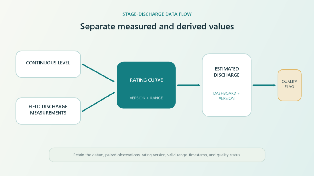
A monitoring system should separate the sensor value from derived data. A water_level or stage field stores the level reading. A discharge_estimated field stores the conversion result and should be accompanied by the rating version, valid range, and quality status.
A useful record may retain:
- raw level and level corrected to the defined reference;
- station identity, datum, benchmark, and sensor-position changes;
- field discharge measurements with their time and method;
- rating-curve or rating-table version and effective date;
- estimated discharge, unit, in-range or out-of-range indicator, and quality flag;
- timestamp, device status, communications status, and inspection notes.
This separation helps operators determine whether a change comes from the river, sensor, elevation reference, formula, or rating update. The dashboard can also flag results outside the measured range rather than presenting them with the same apparent confidence.
Check six items before publishing discharge data
1. Confirm the stage reference
Document the zero, benchmark, sensor position, and field-check method. Treat a bracket or sensor move as a configuration change.
2. Understand the section and control
Identify the channel feature or structure controlling the relation between stage and flow. Record potential sediment, erosion, vegetation, debris, and downstream influence.
3. Plan representative discharge measurements
Use approved methods, competent personnel, appropriate equipment, and site safety procedures. Collect stage-discharge pairs under relevant conditions without assuming one measurement count fits every location.
4. Define the rating and valid range
Document the curve or table, units, source observations, effective period, and treatment of values beyond the measured range.
5. Compare every system layer
Compare the sensor, data logger or gateway, server, and dashboard values. Check scaling, rounding, timestamps, units, formula, and rating version.
6. Verify after conditions change
Inspect and remeasure after floods, sediment movement, channel work, vegetation changes, or evidence of a rating shift. Do not change the model without an approval trail.
Design the AWLR around the decision
A useful AWLR starts with the operational question. For stage trends, design the reference, sensor, logging interval, alarms, and level-based response. For discharge, add field measurement, a stage-discharge model, version control, validation, and quality flags.
Fortuna Argatech can help review monitoring points, sensor technology, data loggers, communications, dashboards, field mapping, and commissioning requirements as one system. To discuss an AWLR and discharge-data workflow, prepare the intended use, site map, expected stage range, elevation reference, channel condition, available gauging data, and response procedure. Contact the Fortuna Argatech team to start a site-based technical review.
Sources
- U.S. Geological Survey. How Streamflow is Measured. https://www.usgs.gov/special-topics/water-science-school/science/how-streamflow-measured
- U.S. Geological Survey. Measurement and Computation of Streamflow: Volume 2, Computation of Discharge, Water-Supply Paper 2175, 1982. https://pubs.usgs.gov/wsp/wsp2175/
- U.S. Geological Survey. Discharge Measurements at Gaging Stations, Techniques and Methods 3-A8, 2010. https://pubs.usgs.gov/tm/tm3-a8/
Share this article
Share this insight with your team.
Related Articles
Similar topics from the same category.
Poor weather station placement can cause 50% data bias. Learn the WMO-No. 8 and Indonesian BMKG siting standards for AWS sensors in industrial and mining sites.
Explore a technical engineering comparison between solid-state ultrasonic anemometers and mechanical cup-and-vane sensors for industrial weather stations.

Technical guide to conductivity sensors: comparing toroidal (inductive), 2-electrode, and 4-electrode contacting probes for industrial water and wastewater.