Comparing Wire Extensometers, Robotic Total Stations, Radars, and GNSS for Mine Slope Deformation
Comparing 8 engineering parameters across wire extensometers, RTS, radars, and GNSS to architect an effective tropical mine slope monitoring strategy.
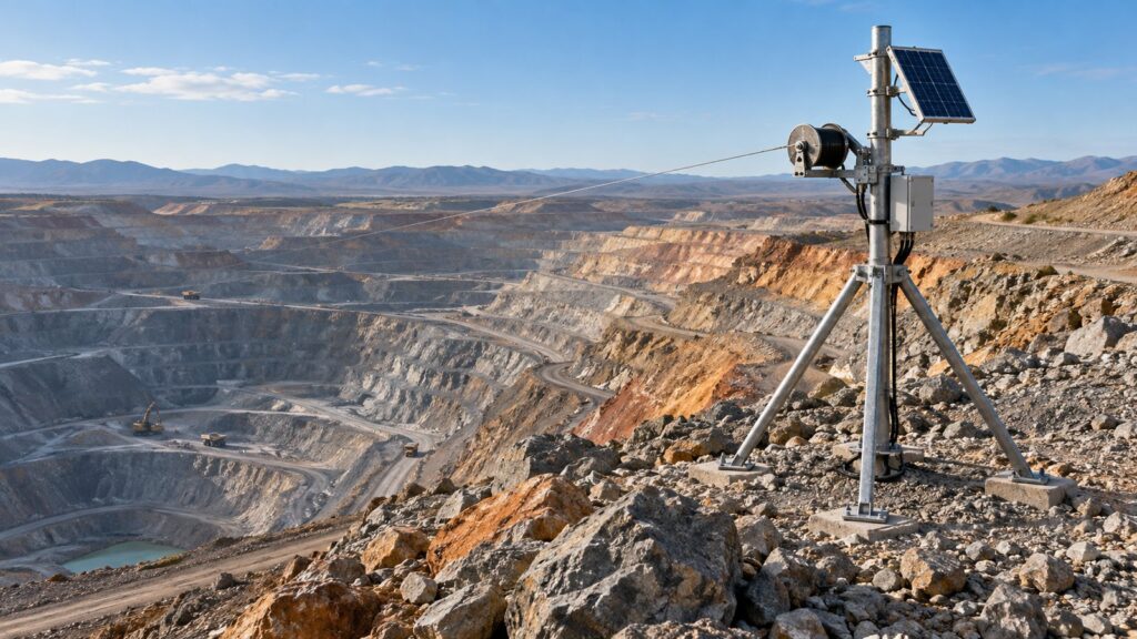
Building an open-pit slope monitoring network is always a trade-off. You weigh capital costs against early warning speed. Data survival during extreme weather also dictates your choices. No single instrument works perfectly everywhere. Every sensor has a blind spot. Take the tropical monsoons. When rainfall blows past 50 mm/hour, catching crack acceleration second-by-second dictates whether your crews get out alive. That speed matters more than anything else.
You have to know the hard operational limits of your gear to meet geotechnical regulations and keep procurement costs sane. This guide breaks down mine slope monitoring wire extensometer vs radar gnss architecture. We look at physical constraints and refresh rates. We also cover actual field costs. The data ties directly into a Trigger Action Response Plan (TARP) following the Indonesian Kepmen ESDM No. 1827/2018 mandate.
The Reality of Mine Slope Monitoring: Why One Technology Is Never Enough
Trusting a single type of sensor creates a dangerous false sense of security in the pit. The global open-pit slope design guidelines from CSIRO demand a defense-in-depth strategy. Indonesian regulations mandate planned, continuous tracking against hard deformation thresholds. Look at Kepmen ESDM No. 1827 K/30/MEM/2018 Appendix II. The law requires redundancy.
Geotech crews running multi-million-dollar radars sometimes think the entire pit is safe. They ignore a hard physical reality. Optical and microwave systems lose accuracy exactly when you need them most. A tropical rainstorm will scatter the signal. Wall movement moving perpendicular to the lens will not register. If you lack an independent tactical early warning device on the ground, you sacrifice emergency alert continuity. The siren might not ring.
Metrology Principles and Measurement Geometry: 1D Mechanical, 3D Optical, Radar Interferometry, and Satellite
These four setups run on completely different physics. A wire extensometer measures physical displacement in one dimension. A steel wire held under constant tension rotates a precision optical encoder across a tension crack. It is mechanical and direct. A Robotic Total Station (RTS) fires a laser. It tracks 3D coordinate positions on a network of glass reflector prisms using distance measurements and digital angle readings.
Slope Stability Radars (SSR) map line-of-sight displacement changes on a wall surface using microwave phase interferometry. They output millions of pixels. GNSS tracks 3D coordinate vector shifts on monument stations via satellite carrier wave phases. You have to understand these mechanics. Otherwise, your slope deformation analysis will contain fatal bias.
Temporal Resolution and Tropical Weather Reliability: Testing Performance During Monsoons and Mine Dust
The speed of your data feed dictates the success of an emergency warning. A wire extensometer delivers the fastest update frequency. It gives you sub-second to 1 Hz data instantly. An RTS needs 15 to 60 minutes to complete a prism network scanning cycle. Radar area scans take 2 to 15 minutes. GNSS runs at 1 Hz epochs or processes batches periodically.
Indonesian pits punish equipment with thick blasting dust and heavy rain. Mechanical wire extensometers hold a massive advantage here. Atmospheric obstructions do not bother a steel wire. RTS hardware is highly vulnerable. Thick fog or severe rainstorms will fully block the optical laser. Thermal air refraction distorts the elevation angle readings.
Radar punches through light dust just fine. However, sudden extreme humidity changes warp the Atmospheric Phase Screen (APS). This forces continuous phase correction fixes. Heavy rain over 50 mm/hour kills the signal strength. GNSS satellites ignore dust and rain completely. Yet their position quality drops in deep pits when the signal bounces off rock walls.
Spatial Coverage and Line-of-Sight Limitations in Steep Mine Pits
You must understand vector orientation to place sensors correctly. RTS and radars demand a clean line of sight from a base pillar across the pit to the target slope. SSR radars share a strict physics limitation. They only detect movement parallel to their microwave beam. They are virtually blind to lateral slope movements.
Extensometers installed physically across the fault zone balance out that radar blind spot. A wire extensometer requires zero cross-pit visibility. GNSS stations need a wide open sky view. The satellite propagation path cannot be blocked by slope walls. This makes GNSS fit for regional monitoring or waste dumps rather than the steep lower pit walls.
Financial and Operational Feasibility Analysis: CAPEX, OPEX, Power Consumption, and Installation Ease
Sensor investments run from dirt cheap to massive capital outlays. Wire extensometers carry the lowest cost burden by far. RTS and GNSS base stations require a medium-category capital expenditure (CAPEX). Slope Stability Radars demand the highest capital procurement value. Their ongoing vendor maintenance fees are equally massive.
Electrical power supply eats into the operational budget. Radars burn 200 to 500 Watts continuously. They require daily diesel generator fueling or jumbo solar panel trailers. RTS and GNSS pull a moderate 10 to 30 Watts. The wire extensometer system holds the mobility advantage because it operates on less than a single Watt. It runs forever on isolated benches using a compact solar panel. You avoid building heavy infrastructure.
Engineering Evaluation Matrix: Comparison of Technical Parameters
We mapped the hard parameters of each deformation monitoring technology in the matrix below. Use this for vendor evaluation and procurement architecture.
| Engineering Parameter | Wire Extensometer | Robotic Total Station (RTS) | Slope Stability Radar (SSR) | Geodetic GNSS System |
|---|---|---|---|---|
| Physics & Geometry Principle | 1D mechanical wire tension (high precision encoder) | 3D electro-optical tachymetry (laser EDM) aiming at reflector prisms | Radar microwave interferometry mapping phase differences (2D) | RTK/differential multi-constellation satellite carrier wave phase |
| Spatial Coverage | Limited local discrete points across active tension crack zones (5-100 m) | Semi-distributed discrete network monitoring prism targets (20-200 targets) | Continuous wide-area scanning at tens of thousands of spatial pixels resolution | Regional surveillance monument points outside the mine area (5-30 targets) |
| Temporal & Sampling | Sub-second continuous (Pure real-time, sampling up to 1 Hz instantly) | Medium-period cycle scanning (15 minutes to 1 hour per target iteration) | Fast-medium area scanning (2 to 15 minutes per rotational cycle) | 1 Hz epochs or continuous weekly static aggregation |
| Extreme Weather Constraints | Weather immune (rainstorms, thick mine dust, or dense fog) | Vulnerable (optical beam blocked during heavy rain/dust, prone to heat refraction) | Disrupted by atmospheric phase variations (APS) during unstable humidity and rain attenuation | Isolated but vulnerable to multipath rock reflection deviations from walls |
| Line-of-Sight Limits | Installed in-situ locally; cross-pit obstruction-free; no visual line-of-sight needed | Critical; requires a stable camera lens line-of-sight to each lens target prism | Critical; blind to displacements intersecting the radial vector firing direction | Pillar view to outer space (open minimum satellite mask angle of 15 degrees) |
| Instrument CAPEX Category | Low (Most economical and modular in terms of initial pit scale procurement) | Medium to high (Telescopic pillar mast arrays and precision motorized instruments) | Highest (Heavy capital investment plus cloud software processing services) | Medium (Reference station and multi-frequency geodetic receiver network) |
| Power Infrastructure Needs | Very low (< 1 Watt); independent compact solar panel/battery per mast | Medium (10-30 Watts continuous); stable concrete mast & medium capacity power panel | High (200-500 Watts); demands logistics diesel genset or large solar payload trailer unit | Moderate (5-15 Watts per unit); permanent reference satellite tower infrastructure |
| TARP Warning Integration | Tactical emergency tripwire; detects acceleration strain and triggers local siren the same second | Multi-point medium-term stability trend surveillance of pit collapse volumes | Wide-area strategic early warning of unexpected crack mechanisms; inverse velocity | Long-term regional mine pillar stability surveillance & area dump volumes |
Table 1. Operational capabilities comparison matrix of tropical mine slope deformation instrumentation technologies.
Integration into TARP: Defining Tactical Frontline vs Wide-Area Surveillance Roles
The Trigger Action Response Plan (TARP) maps out the hazard warning hierarchy in a mine. A wire extensometer acts as a tactical frontline tripwire. Its hertz-frequency resolution catches instantaneous acceleration rates on cracks hitting critical limits. The mechanical switch triggers local evacuation sirens within seconds. It does not wait for a server to process data.
Radars handle strategic early hazard detection across wide areas. They spot unexpected fault formations that geotechnical patrols miss. The SSR maps the inverse velocity collapse time prediction model better than anything else. You combine these systems to stay safe. RTS instruments validate medium-term 3D target shifts. GNSS stations track boundary deformation and slow failures in waste dump slopes.
Layered Monitoring Portfolio Recommendations and Fortuna Argatech Solution Integration
You have to build an instrumentation layout that catches every possible collapse mode. A pit-area SSR setup needs to be backed up by wire extensometer stations. Those wires act as a weather-resistant emergency net right where the heavy equipment fleet operates. They belong on the most critical active cracks.
Fortuna Argatech designs geotechnical instrumentation specifically for these field realities. The Wire Extensometer v4.0 integrates natively with the GEOVOS 1000 Datalogger. It does not just blast raw data over 4G LTE or LoRa. The hardware handles local edge processing right at the mast.
The instrument calculates strain deformation acceleration and fires local hazard sirens on its own. It never waits for a cloud server or a control center connection. If the network drops, the safety relay still works. Contact our geotechnical engineering experts to spec a mine slope monitoring layout that survives extreme monsoon weather.
Share this article
Share this insight with your team.
Related Articles
Similar topics from the same category.
A comparative guide for embankment monitoring instruments: evaluating mechanical settlement plates, magnetic extensometers, and telemetry VW settlement cells.

Learn about digital filter types for monitoring sensors, how to configure them in your data logger, and when to fix the noise source.