Wireless Displacement Sensor: How It Works and Why It Matters
Wireless Displacement Sensor helps monitor displacement wirelessly. Learn how it works, what Argatech publishes, and where it fits.
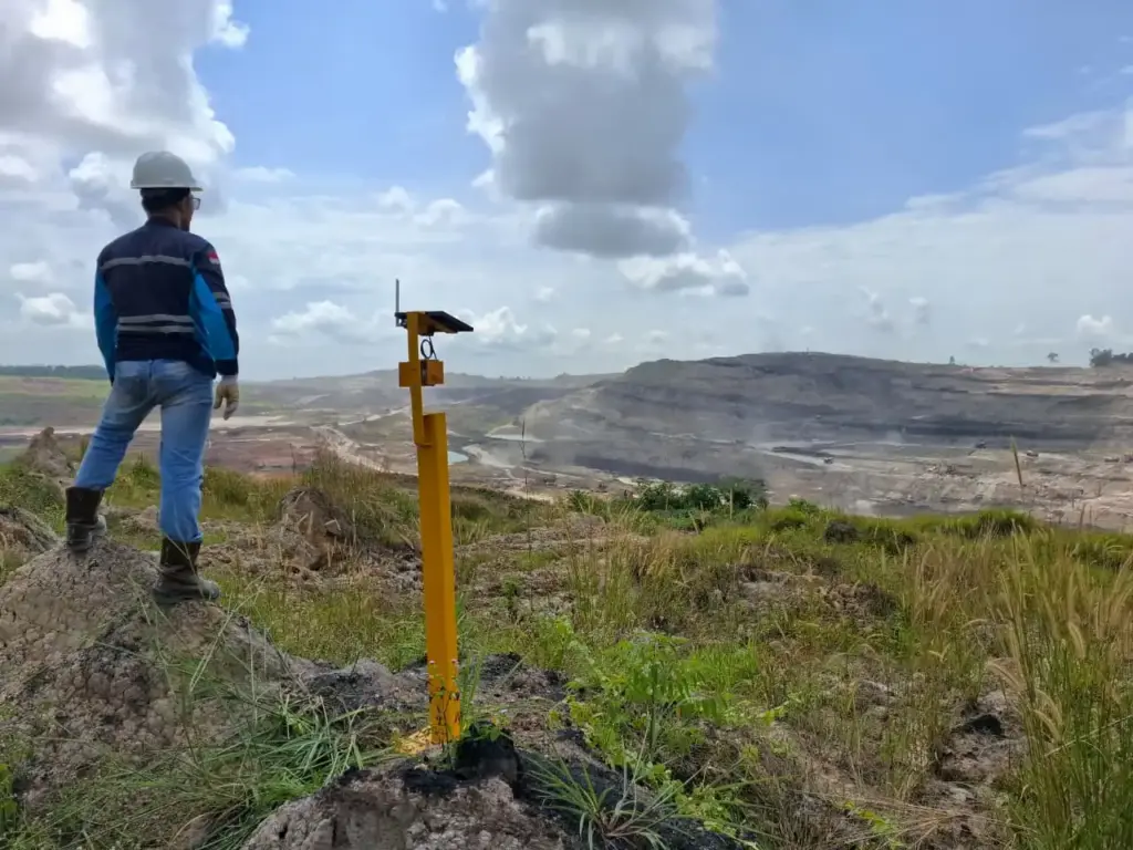
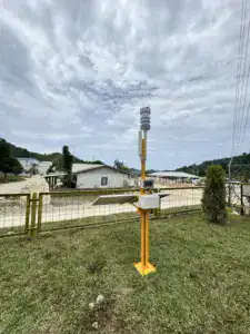
Wireless Displacement Sensor is a device used to measure changes in distance or displacement between two points with precision. On Fortuna Argatech’s official website, it is positioned for mining monitoring with 1 mm resolution, up to 1000 m range, and Mesh Networking.
In geotechnical monitoring, small changes can be the first sign of a bigger risk. That is why this type of sensor matters for early detection and faster response.
What is a Wireless Displacement Sensor?
A Wireless Displacement Sensor reads changes in position between a reference point and a monitored point, then sends the data to a central monitoring system.
The goal is simple: help teams see whether ground or structural movement is starting before conditions become critical.

How a Wireless Displacement Sensor works
The sensor reads displacement
The sensor monitors the distance or displacement between the reference point and the target point.
Data is sent wirelessly
The measurement data is sent to the central system without a long main communication cable.
Mesh networking keeps the link stable
Argatech mentions Wireless Mesh Networking, which means each node can help strengthen the signal so the network stays stable in difficult areas.
The dashboard shows the result
The information is displayed on a dashboard for trend analysis and threshold-based alarms.
Key specs published by Argatech
Argatech’s product page, published on March 2, 2026, lists 1 mm resolution, up to 1000 m range, mesh networking, and scalability of up to 12 sensors in one coordinated network. (Fortuna Argatech, Wireless Displacement Sensor, March 2, 2026, https://argatech.com/sensor/wireless-displacement-sensor/)
Main points:
- resolution: 1 mm
- range: up to 1000 m line-of-sight
- networking: wireless mesh networking
- scalability: up to 12 sensors in one coordinated network
When should you choose it?
This sensor is a strong fit for places that need precise displacement measurement and wireless communication.
Typical use cases:
- open-pit mining sites
- landslide-prone slopes
- hard-to-access areas
- ground deformation monitoring
- geotechnical early warning networks
Wireless Displacement Sensor vs Extensometer
Wireless Displacement Sensor focuses on wireless displacement measurement, while an Extensometer is typically used as part of a broader geotechnical monitoring setup.
For comparison, Argatech also offers EXTENSOMETER for ground movement monitoring.
Main benefits
- data transmission without long main cables
- suitable for large and difficult sites
- supports a stable sensor network
- high resolution for early detection
- can support geotechnical alarm systems
Conclusion
Wireless Displacement Sensor helps teams monitor ground displacement more quickly and flexibly. For mining and slope applications, the mix of high resolution and wireless networking makes early detection more practical.
FAQ
What is a Wireless Displacement Sensor?
A sensor that measures displacement or distance change wirelessly.
What is its main function?
It monitors ground or structural deformation for early detection.
What is its resolution?
Argatech lists 1 mm resolution.
What is its range?
Up to 1000 m line-of-sight.
What is mesh networking?
A network where each node can help reinforce the signal.
Sources
- Fortuna Argatech. (March 2, 2026). Wireless Displacement Sensor – Fortuna Argatech. https://argatech.com/sensor/wireless-displacement-sensor/
- Fortuna Argatech. (no date). EXTENSOMETER – Fortuna Argatech. https://argatech.com/produk/extensometer/

Share this article
Share this insight with your team.
Related Articles
Similar topics from the same category.
Understand how Fortuna Argatech's EWS Tsunami technology works to trigger sirens and instant notifications to accelerate coastal community evacuation.
Understand how the Automatic Weather Station from Fortuna Argatech helps monitor local weather and climate in real-time for various industrial needs.
Discover how the Sistem AQMS from Fortuna Argatech helps monitor air quality in real-time to create a cleaner and healthier environment.