Surface Velocity Radar vs Submerged ADCP: Non-Contact River Discharge Measurement in Flood Conditions
Master the ISO 748 hydrometry guidelines to eliminate loop rating curve hysteresis and prevent sensor damage using non-contact radar technology.
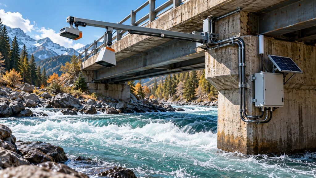
When a flash flood hits, conventional Automatic Water Level Recorder (AWLR) stations often fail to give you the real discharge numbers. If you rely on a static stage-discharge rating curve, you are blinding yourself to hydraulic hysteresis (the loop rating curve). During a fast-moving flood, the energy gradient is much steeper when the water is rising than when it is receding. The actual discharge at a 3-meter water level on the rising limb is significantly higher than that exact same 3-meter level on the falling limb. That error margin can hit 40%.
To eliminate hysteresis, you need to measure actual real-time flow velocity. But putting expensive acoustic instruments inside a swelling tropical river invites disaster. If you are debating surface velocity radar vs adcp (Acoustic Doppler Current Profiler) for flood monitoring, you have to look at how these instruments actually survive extreme conditions.
Radio Waves vs Underwater Acoustics
The fundamental difference between these two technologies comes down to the medium they use. Radio waves travel through the air. Sound waves travel through the water. That single distinction dictates their operational limits.
A Surface Velocity Radar (SVR) is a non-contact instrument. It hangs 0.5 to 30 meters above the water surface, tilted at a 55 to 60-degree angle facing upstream. It fires 24 GHz K-band radio microwaves at the river. The SVR reads the surface velocity using the Doppler frequency shift from the Bragg backscattering reflecting off the ripples on the moving water.
An Acoustic Doppler Current Profiler (ADCP) goes underwater. You mount the transducer to the channel bed or submerge it below the surface. The ADCP fires sound waves into the water column. It divides the depth into measurement cells (bins) and calculates a full 3-dimensional velocity profile based on the time it takes the acoustic waves to bounce off suspended sediment particles and return.
Extreme Flows: Debris Impact and Acoustic Blackout
An ADCP’s 3D velocity profile is fantastic in theory, but it falls apart under extreme field conditions. Tropical flash floods do not just carry water. They carry solid waste, massive logs, and bedload boulders. A submerged ADCP sits right in the impact zone. One heavy log strike will destroy the sensor or rip it off its mount entirely.
Even if it survives the debris, extreme floods shift the riverbed. A bottom-mounted ADCP can easily get buried under a meter of sand and sediment. Once buried, it stops transmitting data until you manually dig it out after the flood recedes.
Worse still is the mud. When suspended sediment levels spike above 30,000 to 50,000 mg/L, you hit acoustic blackout. The mud absorbs the sound waves. The ADCP loses its return signal and fails to read anything.
An SVR sits safely on a bridge or a cantilever pole. It has zero contact with the water. It is completely immune to drifting logs, bed burial, and mud attenuation.
The Index Velocity Method (USGS TM 3-A23)
SVR only measures the surface. It cannot see the bottom. To get total volumetric discharge from a non-contact setup, you have to use the Index Velocity Method (USGS TM 3-A23). This splits the math into two parts: the Stage-Area Rating (water level to wetted cross-section) and the Index-to-Mean Velocity Rating (surface velocity to mean cross-sectional velocity).
You calculate the total discharge by multiplying the wetted cross-sectional area by the mean cross-sectional velocity.
Based on turbulent open channel flow theory, we use a velocity coefficient (k-factor) to relate surface velocity to the depth-averaged velocity. Both ISO 748:2021 and USGS guidelines set a default global surface-to-mean coefficient of 0.85 for natural earth and gravel beds. Field tests consistently show that applying this 0.85 coefficient to SVR data yields discharge estimates with less than 10% uncertainty.
Beating Hydraulic Hysteresis Safely
Because the SVR continuously reads the actual surface velocity, it automatically tracks the acceleration on the rising flood limb and the deceleration on the falling limb. It completely bypasses the loop rating curve error.
More importantly, it keeps your people safe. Measuring floods with non-contact sensors means nobody has to deploy manual current meters, operate risky cableways, or stand on a crumbling bridge during a storm.
SVR Limits: Glassy Water and Wind Shear
Non-contact radars are not perfect. They have physical airspace limits. An SVR needs surface ripples. If the water is glassy and mirror-flat, there are no capillary waves to bounce the microwaves back. The radar needs ripples at least 3 mm high to work.
Wind also messes with the surface layer. A strong wind blowing downstream will artificially accelerate the surface ripples, giving you a falsely high reading. A strong upstream wind will drag the surface and drop the velocity.
Finally, SVR systems rely on a stable channel cross-section. If a massive flood rips out the riverbanks and alters the bed morphology, your Stage-Area table is suddenly wrong. You have to run a new bathymetric survey to update the cross-section geometry in the datalogger.
Decision Matrix: SVR vs Submerged ADCP
When evaluating the engineering constraints against USGS standards, the choice becomes clear based on your operational environment:
| Evaluation Parameter | Surface Velocity Radar (SVR) | Submerged ADCP |
|---|---|---|
| Mounting Principle | Non-contact (airspace) | Direct contact (submerged) |
| Flood & Debris Resilience | Excellent (immune to impact) | Poor (high risk of destruction) |
| Sedimentation Resilience | Immune | Prone to burial and acoustic blackout |
| 3D Velocity Profiling | None (surface only) | Yes (full depth column cells) |
| Personnel Safety | Very Safe | High risk during maintenance |
| Bathymetry Survey Needs | Mandatory post-flood | Mandatory if instrument moves |
A submerged ADCP is the ultimate research tool for mapping 3D velocity profiles in normal, clear water conditions. But if you need a 24/7 operational discharge station on a river known for flash floods, mud, and heavy debris, non-contact SVR is your only realistic choice.
Edge Computing and Flood Telemetry
Getting late discharge data during a flood does you no good, especially if an open-pit mine or a dam sits downstream. Fortuna Argatech builds non-contact hydrometry stations that pair 24 GHz Surface Velocity Radars with GRD-900 Radar Level Meters.
These radars tie directly into the GEOVOS 1000 Industrial Datalogger. The GEOVOS acts as an edge computer, crunching the channel cross-section curve and the ISO 748 velocity coefficient to calculate the real-time volumetric discharge locally at the station.
Our discharge monitoring stations run on low-power solar telemetry. You can configure TARP alarm thresholds directly in the dashboard to trigger automated early warnings before a flood over-tops your assets. Contact the Argatech team to set up a safe hydrometry site survey.
Share this article
Share this insight with your team.
Related Articles
Similar topics from the same category.

8 mandatory monitoring criteria for PROPER Blue rating under PermenLH 7/2025: SPARING, AQMS, B3, waste, peatland, mining, and SIMPEL audit.

Compare TDR and FDR soil moisture sensor principles, dielectric calibration limits for tropical peat, and multi-depth telemetry integration via GEOVOS 1000.

Permen LHK 14/2024 ties SPARING telemetry to daily administrative fines. Understand the formula, sensor risks, and edge validation defense.