EWS Longsor Extensometer: Landslide Early Warning System
Discover the EWS Longsor Extensometer technology by Fortuna Argatech for accurate, real-time ground movement and slope stability monitoring.
Landslides represent a geological disaster threat with significant risks of infrastructure damage and casualties. The National Disaster Management Agency (BNPB) in Indonesia continuously promotes structural mitigation efforts through the implementation of Early Warning System (EWS) technologies to detect soil mass movements.
One of the most globally recognized and effective instruments, including by the United States Geological Survey (USGS), is the extensometer. As a local technology company focusing on the Industrial Internet of Things (IIoT), Fortuna Argatech presents a wireless EWS Longsor Extensometer solution for accurate and real-time slope stability monitoring.
What is the EWS Longsor Extensometer?
The EWS Longsor Extensometer is an early warning system specifically designed to detect, measure, and monitor the movement of soil or rock on slopes with potential for failure (landslides).
The USGS explains that the basic mechanism of a surface extensometer involves measuring the change in distance or strain between two reference points. This device uses a specialized wire or cable connected between a stable anchor area and the moving mass. If any ground shift occurs—even those invisible to the naked eye—the change in wire length is recorded by the sensor as either “stretching” or “shortening.”
How Fortuna Argatech’s EWS Longsor Technology Works
Fortuna Argatech developed this landslide detection instrument by integrating smart telemetry technology. Here is how it works and the key features of the system:
1. High-Accuracy Sensors
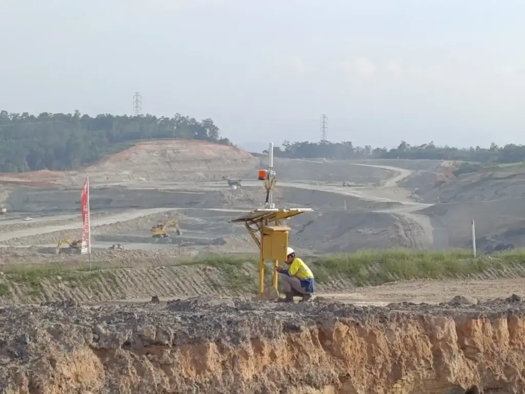
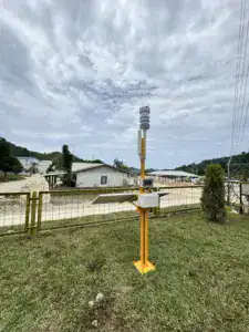
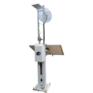
Extensometer sensors are installed at critical movement points. The system can integrate up to 12 sensor slots in a single monitoring network, making it highly effective for securing large areas with a transmission radius of up to 4,000 meters.
2. Advanced Geotechnical Analysis
Beyond simply measuring distance, the system is equipped with Velocity and Inverse Velocity analysis features. This data is highly crucial for geotechnical engineers to mathematically predict the precise “time of failure” for a slope collapse.
3. Multi-Level Hazard Notifications
When sensors detect movement exceeding safe thresholds, the system responds via two channels:
- Local Warning: Activates alarm sirens at the hazardous location to ensure immediate evacuation procedures.
- Digital Warning: Automatically sends status warning notifications (such as SAFE, ALERT, or DANGER levels) via WhatsApp and Email directly to management, emergency response teams, or relevant authorities.
Implementation Across Various Sectors
The application of the Wireless Extensometer is not limited to public disaster mitigation. Fortuna Argatech’s technology is also widely implemented across several sectors, including:
- Mining (Open Pit Mining): Monitoring the stability of open-pit mine walls to protect the safety of workers and heavy equipment.
- Highway Infrastructure: Monitoring cliffs along toll roads or inter-provincial highways that cut through hilly terrains.
- Building Structures & Dams: Serving as part of Structural Health Monitoring to prevent structural failure due to ground deformation.
Similar to our other technological solutions like the ONLIMO System, the implementation of this IoT-based EWS Longsor Extensometer ensures environmental data is always transparently accessible and measurable for responsive decision-making.
FAQ
How does the EWS Longsor Extensometer work?
This device works by connecting a steel wire from a stable anchor point to a moving ground point. If the ground shifts, the wire will be stretched or slackened, and the sensor will record these millimeter changes in real-time.
Who needs this EWS Longsor technology?
Mining area operators, Regional Disaster Management Agencies (BPBD), toll road/highway operators in hilly areas, and plantations prone to ground movement.
How far is the signal range of Fortuna Argatech’s EWS system?
Fortuna Argatech’s wireless telemetry system can reach a monitoring radius of up to 4,000 meters (4 kilometers) between the monitoring node and the data collection gateway.
Does this system provide warnings before a landslide occurs?
Yes. The EWS is equipped with an Inverse Velocity feature that allows the system to calculate ground movement speed, sounding sirens and sending WhatsApp notifications long before a massive landslide happens.
Can the EWS Longsor Extensometer be used in remote areas without power grids?
Generally, this type of IoT monitoring system is designed to be independently powered using solar panels, making it highly suitable for remote locations.
Sources
- National Disaster Management Agency (BNPB). (n.d.). Landslide Disaster Mitigation. https://bnpb.go.id
- United States Geological Survey (USGS). (n.d.). Landslide Monitoring Techniques: Extensometers. https://www.usgs.gov
- Fortuna Argatech. (n.d.). Official Fortuna Argatech Website. https://argatech.com
- Fortuna Argatech Extensometer Product Profile. https://indonetwork.co.id

Share this article
Share this insight with your team.
Related Articles
Similar topics from the same category.
Understand how Fortuna Argatech's EWS Tsunami technology works to trigger sirens and instant notifications to accelerate coastal community evacuation.
Understand how the Automatic Weather Station from Fortuna Argatech helps monitor local weather and climate in real-time for various industrial needs.
Discover how the Sistem AQMS from Fortuna Argatech helps monitor air quality in real-time to create a cleaner and healthier environment.