Choosing Between In-Place Inclinometer and Manual Inclinometer for Slope Monitoring
A technical comparison guide on In-Place Inclinometer (IPI) vs Manual Probe Inclinometer for slope deformation monitoring, risk mitigation, and telemetry.
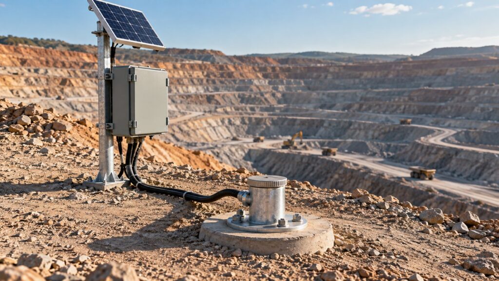
Slope failures almost always begin out of sight. A deep sub-surface plane shears long before the first tension crack ever breaks the surface. For geotechnical engineers, the entire job is figuring out how to detect that invisible movement before it accelerates into a catastrophic failure. Indonesia’s mining safety decree (Kepmen ESDM 1827/2018) does not leave this up to chance: it mandates displacement monitoring to guarantee slope safety factors.
If you look at ISO 18674-3 and ASTM D6230, the tools for measuring this lateral deflection inside a borehole casing boil down to two categories: portable traversing probe inclinometers and fixed In-Place Inclinometers (IPI).
Choosing between an in-place inclinometer vs manual setup is not just a battle over capital expenditure (CAPEX). It is a fundamental decision about how you mitigate failure risk. This guide breaks down exactly how these two systems work, the mathematical realities of measuring displacement, and how telemetry dictates the winner.
Anatomy and Working Principles: Dropping a Probe vs Planting a Sensor String
Both systems live inside an inclinometer casing built with four internal keyways. You align the A-axis perfectly with the expected direction of slope movement. That is where the similarities end. The way they actually pull data out of the ground is completely different.
Manual Traversing Probe Inclinometer
With a manual setup, a technician lowers a cylindrical probe fitted with guide wheels into the casing. Inside the probe is an accelerometer. The technician pulls the probe up from the bottom, stopping exactly every 0.5 meters to take a manual reading of the casing’s tilt. It is a slow, methodical, physical process.
In-Place Inclinometer (IPI)
An IPI system plants a string of MEMS-based tilt sensors permanently inside the borehole. You connect the sensor modules using rigid gauge rods and flexible articulated joints. When the earth moves and the casing bends, the articulated joints allow the string to bend freely without snapping the sensor bodies. Modern IPIs send digital data from dozens of these nodes up a single cable using industrial serial protocols.
The Deflection Math: Turning Tilt Angles into Cumulative Displacement
Both tools rely on basic trigonometry. To calculate the lateral displacement for a single 0.5-meter segment, you multiply the length of the segment by the sine of the sensor’s tilt angle ($d_i = L \cdot \sin \theta_i$).
To see the total deformation profile, the software runs a numerical integration. It assumes the bottom of the borehole is anchored in stable ground that is not moving, and sums all those partial displacements ($D_n = \sum d_i$) up to the surface. This math gives mine planners the exact curvature profile of the casing, pointing an arrow directly at the depth where the shear fracture is happening.
The Critical Trade-Off: Seeing Every Inch vs Seeing Every Minute
When you choose between an in-place inclinometer and a manual probe, you are making a brutal trade-off between spatial resolution and temporal continuity.
The manual probe gives you a flawless, high-resolution picture of the entire borehole depth. You get a data point every half-meter. But because it requires a human to drag a probe up a pipe in the rain or heat, you only get that picture once a week, or maybe once a month. If heavy rainfall or blasting triggers a rapid slope failure between your weekly surveys, you will miss the acceleration phase entirely.
The IPI solves the time problem. Connected to a datalogger, an IPI records the slope’s movement every few minutes, 24/7. This continuous data stream lets you watch the lateral displacement velocity in real-time, giving you the exact numbers you need to trigger a Trigger Action Response Plan (TARP) early warning alarm. The catch? You lose spatial resolution. If you only buy enough IPI sensors to cover a specific 10-meter zone, and a new slip plane develops outside that zone, your system is completely blind to it.
Validating the Data: Physical Checksums vs Mathematical Drift Correction
In geotechnical monitoring, bad data is worse than no data.
Manual probes validate themselves physically. The technician runs a dual-pass procedure: they measure the whole borehole at the normal $0^\circ$ position, pull the probe out, spin it $180^\circ$, and do it again. The software calculates a checksum from the difference, instantly neutralizing any mechanical zero-offset in the sensor. If the numbers don’t match, you know the probe is out of calibration.
You cannot pull a 50-meter IPI string out of the ground to spin it $180^\circ$ every Tuesday. IPIs have to rely entirely on the stability of their MEMS chips and mathematical thermal correction. The sensors must constantly read the internal borehole temperature and automatically calculate the microscopic thermal expansion of the sensor body to prevent data drift over the years.
The Nightmare of Casing Pinching and Instrument Rescue
Engineers often forget one brutal reality of slope failure: the earth shears with massive force. When deformation concentrates on a weak plane, it will sharply pinch or shear the plastic casing pipe in half.
If the casing pinches while you are relying on a manual probe, the probe simply cannot pass the blockage. That borehole is dead. But financially, you only lost a plastic pipe. The expensive probe was safely in the technician’s truck when the earth moved.
IPI strings face a completely different threat. Your expensive sensor string is trapped underground. If the slope fails suddenly, the IPI string will be crushed or buried permanently. This means your geotechnical emergency response plan must include a hard TARP threshold not just for evacuating the haul trucks, but for rushing out to rescue the high-value IPI string before the pipe shears completely.
The Hybrid Strategy: Manual First, IPI Second
To balance CAPEX and safety, the industry usually blends the two methods.
First, you drill the hole and use a manual probe for a few weeks. This maps out exactly where the active shear plane is located. Once you know the slip surface is sitting exactly at 45 meters deep, you buy a targeted IPI string. You don’t buy 100 meters of sensors. You buy 5 sensor modules, drop them precisely across the 40–50 meter zone, and hook them up to a telemetry logger. You get 24/7 real-time monitoring on the critical fracture zone without bankrupting the project.
Telemetry Integration: Taking the Human Out of the Loop
An IPI is practically useless if someone still has to walk out to the borehole to download the data. The true power of the instrument unlocks when it connects to a wireless telemetry network.
Fortuna Argatech integrates in-place inclinometers directly with the Geovos 1000 datalogger using industrial RS-485 Modbus RTU protocols. The Geovos 1000 acts as the field command center, firing telemetry data wirelessly from the remote slope to the central server.
The dashboard takes that raw tilt data, crunches the integration math, and displays the visual deformation profile. Because the system tracks the velocity (mm/day) automatically, geotechnical engineers can tighten their TARP alarm configurations and let the software handle the early warning alerts.
Decision Matrix: When to Pull a Probe and When to Plant an IPI
If you are currently planning a geotechnical site survey, use this matrix to justify your instrumentation investment:
| Decision Parameter | Manual Traversing Probe | In-Place Inclinometer (IPI) |
|---|---|---|
| Data Acquisition Frequency | Periodic (weekly/monthly) | Continuous (real-time per minute/hour) |
| Spatial Profiling Resolution | Full, seamless (every 0.5 meters) | Targeted (only where sensors hang) |
| Field Calibration Validation | Physical $180^\circ$ rotation checksum | Mathematical temperature & drift compensation |
| Asset Risk During Failure | Very low (only the pipe is lost) | Very high (expensive string gets buried) |
| Labor Requirement | Intensive (requires humans at the borehole) | Minimal (after the initial installation) |
| TARP Alarm Triggering | Very slow (massive potential for blind spots) | Instant and automated |
Use a manual probe for preliminary site surveys, baseline regional monitoring, or projects where you have dozens of boreholes but expect very slow deformation.
But if you are managing an active, high-wall mining slope or a critical dam structure where missing a sudden acceleration could cost lives, an IPI tied to a telemetry system is not optional. It is mandatory. Combining the two methods gives you a resilient system that complies with ESDM regulations, protects your workers, and stops you from blindly throwing CAPEX into the ground.
Share this article
Share this insight with your team.
Related Articles
Similar topics from the same category.
Poor weather station placement can cause 50% data bias. Learn the WMO-No. 8 and Indonesian BMKG siting standards for AWS sensors in industrial and mining sites.
Explore a technical engineering comparison between solid-state ultrasonic anemometers and mechanical cup-and-vane sensors for industrial weather stations.

Technical guide to conductivity sensors: comparing toroidal (inductive), 2-electrode, and 4-electrode contacting probes for industrial water and wastewater.