Landslide in Pasaman: Lessons from Bukit Panjuik & How to Reduce the Risk
Summary of the Panjuik Hill Landslide (2014) in Pasaman + explanation of what a landslide is and its triggers according to BNPB & USGS, as well as general risk reduction guidelines.
Bukit Panjuik landslide – Pasaman Regency has hilly and sloped areas that can become prone to landslides during the rainy season. This article summarizes a landslide incident reported by the media in 2014 at Bukit Panjuik, explains the basic concept of landslides based on official definitions and scientific references, and ends with general risk reduction steps.
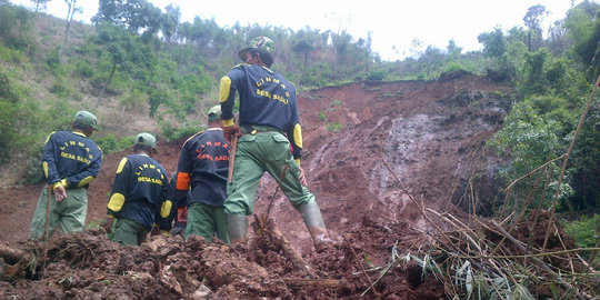
Summary of the Bukit Panjuik Incident (2014)
Media outlet ANTARA reported on Friday, April 25, 2014, that a landslide occurred at Bukit Panjuik, Kampung Landai, Pasaman Regency, West Sumatra. At the time the news was published, it stated that three residents were “suspected” to have been buried/killed (meaning the victim status in the report was not yet a final confirmation). ANTARA also linked the incident to heavy rainfall beforehand, as well as challenges in the search process due to difficult terrain and the risk of further landslides.
What Is a Landslide?
In simple terms, a landslide is the movement of soil and/or rock mass down a slope when slope stability is disturbed. According to Badan Nasional Penanggulangan Bencana (BNPB), a landslide is a type of mass movement of soil or rock (or a mixture of both) that moves down or out of a slope due to instability of the slope material. Meanwhile, United States Geological Survey (USGS) defines a landslide as the movement of rock, earth, or debris down a slope.
Why Is Rain Often a Trigger?
USGS explains that landslides can be triggered by various factors, including rainfall, changes in water conditions, erosion, earthquakes, volcanic activity, human activity, or a combination of these factors. In its publication on “triggers and types,” USGS describes a “trigger” as an external stimulus that can initiate a landslide for example, intense rainfall.
In simple terms for general readers: when water infiltrates soil and slopes, the physical condition of the slope can change (for example, the material becomes more saturated and heavier), making it easier for the slope to lose stability and move.
Managing Landslide Risk in Hilly Areas of Pasaman (General Principles)
This section provides general educational guidance, not official local government instructions. Identify vulnerable areas:
- Identify vulnerable areas: Steep slopes, Roadside cliffs, Riverbanks affected by erosion, Locations with a history of landslides
- Reduce exposure during prolonged rainfall: Postpone activities near slopes or cliffs whenever possible.
- Regularly monitor slope conditions: Especially around homes, farms, or access roads.
- Prepare a family emergency plan: Safe evacuation routes, Meeting points, Local emergency contacts (such as the regional disaster management agency), Basic emergency supplies
For key preparedness messages, BNPB provides visual materials titled “Siaga Bencana: Longsor” (Before / During / After a Landslide).
https://bnpb.go.id/siaga-bencana/longsor-mencegah-dampak
https://bnpb.go.id/siaga-bencana/longsor-saat-terjadi
https://bnpb.go.id/siaga-bencana/longsor-setelah-terjadi
When to Be Extra Alert and How to Respond in Emergency Situations (General Guidance)
- If rainfall is very heavy or lasts for a long time, increase your level of alertness especially if you live or work near slopes.
- Prioritize personal safety: avoid approaching cracked or suspicious slopes, and follow instructions from local authorities if evacuation is ordered.
- After a landslide, do not return too quickly before safety assessments are completed, as secondary landslides may occur.
Landslide Extensometer (Fortuna Argatech)
If you manage slopes near residential areas, roads, or work sites, one approach to risk reduction is regular slope movement monitoring to provide early signals when deformation begins to increase.
The Fortuna Argatech Extensometer is a displacement monitoring device that can be installed on slope areas to track changes over time.
- General components: Main station / data logger, Displacement sensor, Power supply (e.g., AWD), Modem / data communication system (optional, depending on site needs)
- Purpose: Monitor movement trends and support operational decision-making (for example, restricting access when movement trends increase).
- Possible analytics: Movement trend analysis, Evaluation methods such as inverse velocity (when relevant) to help interpret acceleration of deformation
Landslide EWS for Real-Time Monitoring
Good manual preparation is an important first step. However, for homes in high-risk zones or near steep slopes/cliffs, continuous monitoring with technology can provide faster and more accurate early warnings.
Fortuna Argatech Landslide EWS is a monitoring system that integrates:
- Multi-Sensor Monitoring: Geotechnical sensors (extensometers, inclinometers, etc.) detect ground movement with precision.
- Real-Time Data: Sensor data is transmitted via wireless networks to an online dashboard that can be accessed anytime.
- Automatic Alerts: When dangerous deformation is detected, the system automatically sends alarms and notifications.
The Landslide EWS website represents a solution from Fortuna Argatech. If you would like to discuss EWS needs for vulnerable areas from risk mapping and warning scenarios to response SOP design you can request a consultation and demo so the system design matches field conditions.
How It Works (Simple Explanation)
Sensors installed upslope and along the slope send data to a central system via an IoT network. The system compares parameters such as rainfall intensity, slope inclination changes, and groundwater pressure. If certain combinations indicate increasing risk, alerts can be triggered based on predefined thresholds.
FAQ
1) What is the definition of a landslide according to BNPB?
BNPB describes a landslide as the movement of soil/rock mass (or a mixture of both) down or out of a slope due to slope instability.
2) What are common landslide triggers according to USGS?
USGS states that triggers may include rainfall, water condition changes, erosion, earthquakes, volcanic activity, human activities, or a combination of these factors.
3) What does “landslide trigger” mean?
USGS defines a trigger as an external stimulus that can initiate a landslide, such as intense rainfall.
4) What was reported about the 2014 Bukit Panjuik landslide?
ANTARA reported a landslide in Bukit Panjuik, Kampung Landai, Pasaman Regency. At the time of publication, it stated that three residents were “suspected” to have been buried/killed.
5) Does this article confirm the final number of victims?
No. This article only summarizes the status stated in the source used (ANTARA), which used the word “suspected.” Final confirmation would require official follow-up sources that explicitly confirm the status.
Source
- ANTARA. (25 Apr 2014). Tiga warga Pasaman diduga tewas tertimbun longsor. www.antaranews.com
- BNPB. Definisi Bencana. bnpb.go.id
- USGS FAQ. (updated 1 Jul 2025). What is a landslide and what causes one?. www.usgs.gov
- USGS Publication. (2002). Landslide triggers and types. www.usgs.gov
- BNPB “Siaga Bencana: Longsor” (materi visual):
